AI for Biodiversity
The Challenge
Invasive aquatic plants (IAS), when introduced into ecosystems not adapted to their presence, often significantly alter population dynamics, causing biodiversity loss and reducing the quality of life for local communities — for example by clogging waterways, hindering recreational and touristic activities, and even posing risks to human health. At the same time, traditional management of IAS entails heavy costs for public administrations and responsible entities, and is often unsustainable in the long term.
The European Union periodically publishes a list of exotic invasive species that threaten biodiversity, habitat integrity, and human activities, with serious economic consequences. This applies also in the Turin area, which is the focus of the project, in particular in two pilot zones of the Po river: first near the Murazzi, second at Villafranca. In both locations the proliferation of invasive species has become problematic due to many factors, among them climate change, negatively affecting native species, tourism, and the population, causing many inconveniences.
Two SMEs specialized in Green ICT and Footprint/Circular Economy, utilizing the services of a research excellence institution (UNITO – Water Ecology and Biochemistry), are developing RiparianEye, a platform whose purpose is the use of biomass for energy, pharmaceutical, cosmetic and nutraceutical purposes.
The Project: Innovation at the Service of Sustainability
Through this project, strategic tools are to be analysed and proposed for reusing these resources, transforming them from an environmental problem into a sustainable opportunity in a circular economy perspective, generating new economic flows and reducing environmental impact. The project uses “AI for Biodiversity” — from monitoring IAS, mapping riverine ecosystems, to optimizing management strategies — with a highly interdisciplinary team that guarantees a holistic vision and promotes the development of cutting-edge sustainable solutions.
Zirak and Studio Fieschi, SMEs specialized in Green ICT and Footprint / Circular Economy, in collaboration with a top Research Institution (UNITO – Water Ecology and Biochemistry), will develop three functional components, which will be tested in a pilot project to promote the use of biomass for energy, pharmaceutical, cosmetic and nutraceutical applications:
-
- The first component, LAB, concerns the laboratory and focuses on the research of the potential of biomass, with particular attention to green energy production and extraction of high-value biomolecules for pharmaceutical, cosmetic and nutraceutical applications.
- The second component, AI, represents the technological innovation needed to trace species from aerial data, quantify the abundance of the resource through creation of ad-hoc datasets, build artificial intelligence models and model their distribution.
- Finally, the LCA component focuses on life-cycle analysis, with the aim of evaluating the potential impact of different usage options in terms of circular economy and environmental sustainability.
These three components work synergistically to create a flexible and modular platform, applying AI techniques to aerial data to monitor and map biomass with precision, generating concrete benefits in various fields:
-
- Economic: Converting waste into resources, creating jobs and enhancing local resources.
- Environmental: Reducing waste, protecting biodiversity and conserving habitats, decreasing the need to extract non-renewable natural resources.
- Social: Mitigating risks to human health associated with invasive species, and promoting a balanced ecosystem.
- Political: Strengthening regional resilience and positioning Piedmont strategically in sustainable technologies.
The project is part of a company strategic line focused on several issues of the river ecosystem, currently at a prototypal stage, which allows for analysing abnormal conditions of a river or its surrounding area.
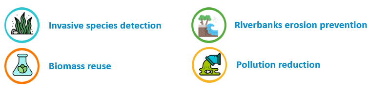
RiparianEye – features
Zirak’s Role
As project lead, Zirak conceived the RiparianEye – Biomass project, and is developing the end-to-end platform, including:
-
- Pre-processing of aerial data (satellite, multispectral imagery)
- Management of large volumes of data in a bespoke backend
- Inclusion of field data collected by project partners
- Development and tuning of computer vision and artificial intelligence algorithms as needed
- Analysis of various vegetative indices, multispectral bands and their combinations
- Early alert management
- The presentation layer through an efficient and intuitive frontend
Zirak’s goal is that, by conveying its know-how through RiparianEye, to become a reference actor for the circular economy in Piedmont by means of Big Data Analytics, Computer Vision and Artificial Intelligence tools.
Early warning system
As a byproduct of the project, an early warning system has been developed that enables a solid and efficient process: from satellite data to secure, expert-validated notifications sent to the municipality or the authority responsible for field interventions.
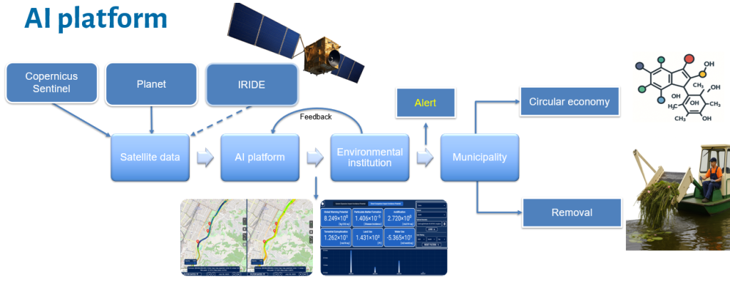
The Artificial Intelligence platform, consisting of an intuitive interface for researchers and an automated daily data analysis section, processes satellite data from multiple constellations to optimize results. From this analysis, automatic notifications are generated and sent to an environmental institution, which validates them using geospatial indications that help optimize the work of field experts. Instead of having to monitor the entire riparian area, biologists receive precise guidance on zones with a higher probability of presenting critical issues.
Field observations by biologists serve as direct feedback for the platform and the AI models, progressively improving the quality of the notifications. When the environmental institution confirms the conditions and experts deem an intervention by the municipality or the authority responsible for removal or resource utilization (e.g., biomolecules, biohydrogen) necessary, the alert is triggered in a targeted and secure manner, thanks to expert validation.
This approach aligns with what Andrej Karpathy defines as “tight feedback loops” between AI and humans: short and continuous cycles of supervision and correction that direct the power of models toward concrete and reliable goals. The aim is not to replace humans, but to build a system in which artificial intelligence constantly learns from real-world data and human verification, reducing errors and increasing trust. At the same time, the platform provides experts with increasingly targeted insights, making their work easier and more effective.
To explore the concept further, one can refer to the video “Software 3.0: Software in the Age of AI”, where Karpathy describes the need for tight feedback loops between AI and human supervision.
An Intelligent and Intuitive Interface
Our frontend combines interactive geospatial visualizations, advanced analytical tools, and customized data management to turn complex information into concrete decisions. With modular and responsive design, it ensures smooth performance on any device, offering:
-
-
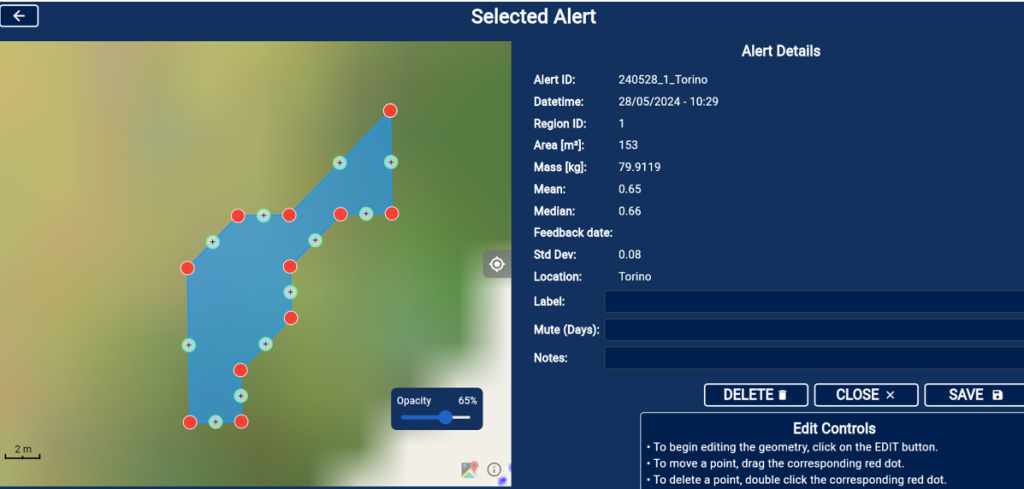
Dynamic maps to explore raster and vector data with customizable filters.
-
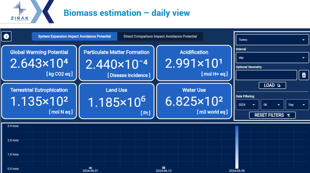
Analytical tools such as temporal analyses, custom formulas and intelligent notifications.
-
Personalized dashboards to manage data, preferences and reports with ease.
- Feedback tools from field experts (during the project, the DBios Department of the University of Turin), to iteratively refine the model, optimize field visits, and enable the extraction of high-quality data for the institutions responsible for the removal or reuse of resources.
-
Our frontend is designed to be scalable, extensible, and fully interoperable with geospatial standards.
It offers an interactive geospatial platform for the analysis of environmental and territorial data, allowing:
-
-
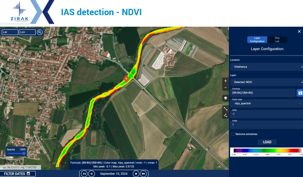
Visualization of raster and NDVI data, highlighting areas with different vegetation intensities via a colour scale (for example, from red to green).
-
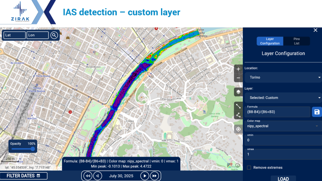
Tools to configure desired indices and bands, defining custom formulas, adjusting minimum/maximum values and selecting colour maps.
-
Full interaction with the map.
-
Temporal analysis allowing comparative study of data over time.
-
Custom outputs.
-
Dynamic interaction with tools to navigate the map, adjust layer opacity, add annotations or custom pins.
-
This interface is designed to support data-based environmental decisions, facilitating vegetation monitoring, land use planning and analysis of natural resources.
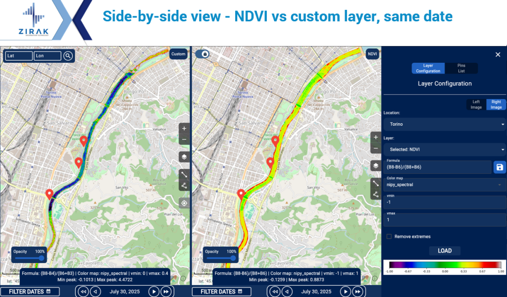
The interface also offers side-by-side comparison of geospatial data, enabling the analysis of temporal variations, differences between two datasets, and the comparison of different indices on the same dates or at different points in time.
Each panel can be configured individually, with tools to customize formulas, color maps, and parameters. Ideal for monitoring environmental changes, such as vegetation dynamics, it provides a smooth interactive experience and data overlay.
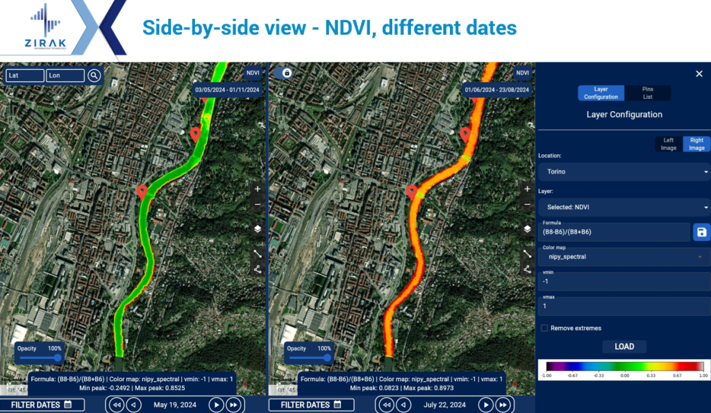
The interface integrates an advanced temporal analysis system, allowing users to select dates or time ranges to dynamically observe and monitor variations in geospatial data, such as changes in vegetation or resource distribution.
NODES Ecosystem

![]()
Project partners
RiparianEye is part of the NODES project, receiving funds from MUR – Missione 4, Componente 2, Investimento 1.5 – Creazione e rafforzamento di “Ecosistemi dell’innovazione”, costruzione di “leader territoriali di R&S” – of PNRR with grant egreement no. ECS00000036